Ladakh….The Forbidden Land…….The Land of The God……The Land of Endless Discovery…….what ever you Call it.
 |
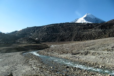
| Ladakh & Indus River |
Bounded by two of world’s mightiest mountain ranges, The Great Himalaya and The Karakoram, it lies athwart two others, The Ladakh Range and The Zanskar Range. Its basic contours, uplifted by the enormous tectonic movements, have been modified over the millennia by the opposite process of erosion, sculpted into the form we see today by wind and air.
Ladakh, the high altitude desert, sheltered from the rain bearing clouds of the Indian Monsoon by the barrier of Great Himalaya, was once covered by an extensive lake system, the vestige of which still exist on its south east plateaus of Rupsu and Chusul.
It lies at altitudes ranging from about 9000 ft (2750 m) at Kargil to 25,000ft (7600m) at Saser Kangri in the Karakoram. With bright Sun its Temperature during Summer may reach 270C to mere -200C in Winter. Ladakh is the only wonderland in the Earth where people sitting in sunshine with their legs under the shade suffer from Sun stroke and Frostbite simultaneously.
Travelers from the world can traverse two ways to reach there. The road from Srinagar passes the ZoZi -la pass and follows next The Drass , kargil, Mulbek and then meets the road from Manali at Upshi, The Historical Heartland of Ladakh. It’s a couple of day journey with one night stay at Kargil.
Approaches to Ladakh
 |
| Keylong |
Travelers from the world can traverse two ways to reach there. The road from Srinagar passes the ZoZi -la pass and follows next The Drass , kargil, Mulbek and then meets the road from Manali at Upshi, The Historical Heartland of Ladakh. It’s a couple of day journey with one night stay at Kargil.
I personally preferred the second approach, the road from Manali. Open for barely three months of the year (from early July to September), it passes through a country so barren as to be entirely without settled habitation. It crosses the Lahul district, the valley of Chandra and Vaga Rivers offers a trans-Himalayan landscape. To traverse along this path we need to cross several high altitude passes starting with Rothang pass (13050 ft), cutting across not only the great Himalaya itself but also The pirpanjal range to its south. We camped overnight at Keylong in some small tents. Starting at morning we reached Keylong around six in the afternoon. The deeming sunlight was about to fade away and the magnificent full moon flooded its mystic, magical, tranquil glory over the Kelong valley surrounded by the glowing snow caped mountain all around.
Next day early morning (around 4 AM) we hairpined to Barla cha la (16000ft) pass that is perhaps unique being a tri-junction and after that the barren landscape became positively lunar, dusty plains scattered with boulders, and the occasional patch of pasture reminded us of the existence of vegetation in the world. This pass is the crossing point of The Himalayas. Within a few minutes we were at Sarchu, the last village of Himachal Pradesh, crossing which we laid our footprints at the magical state of our country, Jammu & Kashmir.
 |
| Vaga River |
 |
| Barla Cha La |
There remained the Zanskar Range to be crossed along with its mighty passes, the Lungalacha –la (16600ft) and the Taglang –la (17469ft), the second highest motorable path of the World. The awesome beauty along the road we experienced was indescribable…….one can only see and feel this dust-devil landscape with only some seasonal entrepreneur who erected their tents to serve basic needs of us, the traveler.
 |
| Landscape after Sarchu |
 |
| Pang |
After Taglang-la the road gradually and steadily descends to UpShi, the junction point to Kargil and Srinagar bound road. Oh….at last we reached the cozy Guest House at Leh. It was almost 8 o’clock in my watch but still the groom sunlight made me feel the cold and drama of the city. We sheltered at SIA-La guest house, offerd by a glass of warm milk-butter tea and a piece of Ladhaki Bread.
One can also fly from Delhi or Srinagar over to Leh but they need to acclimatize themselves for a full day just to cope up with sudden gain of altitude. Leh is placed at an altitude around 12,000 to 13,000 ft.
Places of Interest:-
As we did you can reserve one full day for a side tour along the Leh city. That includes the enchanting Santi Stupa, the Spituk and Hemmis Monastery ( the biggest), Shey and Old Leh Palace, The Sindhu Ghat , Stok Palace and the Hall of Fame of Indian Army.
 |
| Santi Stupa, Leh |
Then you can plan for the distant trip. We divided the ladakh homeland in three regions, each vibrant with their distinct natural existence.
 |
| Hemis Monastery |
 |
| Landscape fro Shey Palace |
 |
| Distant Mountain Range |
 |
| Indus ( Sindhu) River |
The Nubra Valley Region
Route : Leh – Khardung La – Khalsar – Deskit – Hundar – Pramanik- Leh
The very name Nubra Valley is inherited from the river Nubra that drains the eastern and western side of Saser Spur, the eastern most outcrop of the Karakoram. The Nubra and Shayok rivers accompany the valley above and below their confluence and finally engross the Indus River at Baltistan. This route took us to the great Khardung – La pass (18,300ft), the highest motorable route of the world. It was snowing all around when we reached there with its temperature around -160 Celsius. Believe me it was 18th.September. The cold & chill could not confine us inside our black vehicle as the place offered the amazing view all the way south over the whole Indus Valley towards the seemingly endless peaks and ranges of the Zanskar Range and north to the giants Saser Massif of the Karaloram.
A couple of hour was too little to quench the thirst but we forwarded towards our extreme destination over a small village, Khalsar. Around 12 noon we reached our first target, Pranamic. A hot spring was waiting there for us and Siachen Glacier was asking our inner being to become concurred. But the benevolent army officers turned our car towards Deskit village, where we stayed overnight. Early morning we merged steadily uphill to reach Old and New deskit monastery and found ourselves surrounded by the lashing mountains as if we are on the laps of a big fellow. We forwarded towards the amazing sand dune of Hundar.
Here exists a small population of Bactrian camel, shaggy double humped animals, which in the old days were used as pack animals on the Central Asian Trade Route. Both Hundar and Deskit lie around 10,000 ft and are one of the wonders of the world, the unimaginable blend of Sand dunes, deserts and snow caped mountains. We returned from there to leh. How?
It was almost 10.30AM as we started our return journey towards Leh. The initial few hours was uneventful. But soon the sky was covered with white clouds as we were approaching Khardung -La top. Soon it started snowing a little and we just came out of the car to enjoy the snowfall. Our driver warns us that we have to move quickly......otherwise we might got stuck if snowfall picked up. As we were proceeding it eventually increased and just before 1 km of the Top the road was completely covered with fresh snow. The car was sliding dangerously. Having had no other options we came out of the car and Tashi Bhai fixed the chain over the tire of our car.
But it was still sliding......and we had to walk over the snow clad road.....with temperature around -16......with complete white out......with heavy snowfall.....and Tashi Bhai followed us with the black car carefully & slowly. We were walking for our lives..........praying to survive.....and at last the car came under control. We boarded it again........snowfall continues.....But we escaped the horror....That day we realized how helpless man could be under the laps of nature......Beauty and the beast......Experience of life time.
Pangong Lake Circuit